Showing posts with label Bulacan. Show all posts
Showing posts with label Bulacan. Show all posts
Friday, August 25, 2017
LIST: 99 Villages and Subdivisions Traversed by the Valley Fault System
The Valley Fault System is a dextral strike-slip type fault that traverses primarily in the eastern portion of Metro Manila and other provinces such as Bulacan, Rizal, Cavite, and Laguna that sums up to a total length of 146.71 kilometers. It traverses a densely populated area in southern Luzon piercing through over 90 private villages and subdivisions with over 6,000 buildings on top of the fault line.
Wednesday, August 16, 2017
Barangays and Buildings Traversed by the Valley Fault System
The Valley Fault System, which is composed of the West and East Valley Fault traverses to several provinces all the way from Bulacan in the north to Laguna in the south with a total length of 146.71 kilometers. This also includes the whole length of Metro Manila from Quezon City all the way down to Muntinlupa City. About 80 barangays are affected and more than six thousand structures sitting on top of the fault line with over 2 million people in the danger zone.
Wednesday, May 20, 2015
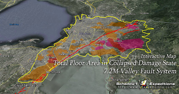
Interactive Risk Analysis Map of the Valley Fault System Earthquake
Last June 2013, PHIVOLCS has released a series of risk analysis scenario maps pertaining the West Valley Fault System in case its movement triggers a large earthquake within Metro Manila. These maps provide structural stability analysis of localities that can be affected in case a 6.5M or 7.2M earthquake jolts the metropolis due to the movement of the Valley Fault System that is estimated to be active in every 300 +/- 100 years.
Friday, July 11, 2014
Interactive Map for the West and East Valley Fault Line on Rizal, Metro Manila, Laguna, Cavite
The West and East Valley Fault System span from Angat, Bulacan all the way down to Carmona, Cavite and Calamba, Laguna and is the most feared event that could hit Metro Manila in case the fault system moves as it may cause larger than 7.0 magnitude earthquake. As of the meantime, disaster resiliency assessors have been saying that the country is not prepared for a calamity such as this. Schadow1 Expeditions has acquired the fault line data from PHIVOLCS and traced it on top of OpenStreetMap and Google Earth.
Subscribe to:
Posts (Atom)


