This year has been the most active year for the contributors for Openstreetmap (OSM) data in the Philippines. One of the major contributor to its growth would be due to the record-breaking updates that happened due to the humanitarian activation of the Visayas for the mapping advocates to focus on the Typhoon Haiyan stricken areas of the Philippines which led to over 1 million updates in just a week since the typhoon has struck the country. The mapping data for the Philippines has been used for the mobilization of various humanitarian missions in the country. The following is the assessment of Schadow1 Expeditions regarding the growth of the Openstreetmap data using the Routable GPS Map of the Philippines based on OSM data as the basis.
In just a span of one year, the Mapsource installer for the Routable GPS map of the Philippines based on Openstreetmap has grew from 32.8MB to 48.2MB.
 |
| 09-2012 Map splits |
 |
| 12-2013 Map splits |
As Mapsource can only handle a limited file size for a map, the whole Philippines need to be split to several files so it would work with GPS systems. Last 2012, the map data for the Philippines was split into five files. Before the humanitarian activation due to the Haiyan / Yolanda crisis, the map of the Philippines was split to 10 tiles. As the data increased further, last December 1 2013 update of the map of the Philippines, the map is now split into 13 image files.
The notable data increase can be seen mostly on areas where the Environmental Science for Social Change (ESSC) has organized participatory mapping training on local government units in different parts of the country, the Humanitarian Activation of the Visayas, mapping expeditions to remote islands in the Philippines and mountaineers who provided trails to different peaks in the country.
 |
| 2012 Map of Tacloban City, Leyte rendered on Garmin Basecamp |
 |
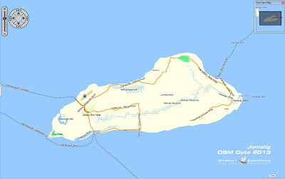
| 2012 Map of Jomalig Island |
 |
| 2012 Map of Camiguin and the Hibok-Hibok Volcano |
 |
| 2012 Map of Palaui Island |
 |
| 2012 Map of Mount Ugu |
 |
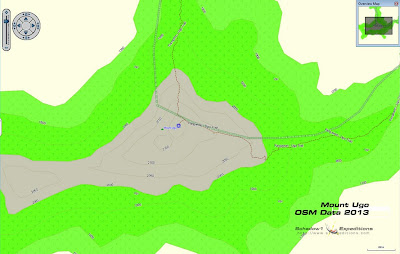
| 2013 Map of Mount Ugu and its trails |
The routable GPS map of the Philippines based on Openstreetmap data including the updates from our mapping expeditions above can be downloaded for free at our
#mapPHL page so a Filipino would not be a stranger to his motherland. The map can be uploaded to compatible GPS devices which can be used for navigational assistance on vehicles or as an outdoor recreation guide while on hiking trails and bicycle tracks.


No comments:
Post a Comment